By Dean Murray
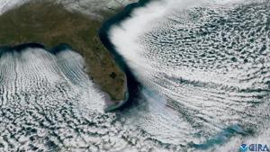
The Arctic blast that plunged much of Florida into a deep freeze also produced mesmerising cloud streets, as seen by satellite.
Cloud streets are elongated rows of cumulus clouds aligned parallel to the prevailing wind direction.
View this post on InstagramA post shared by NOAA Satellites (@noaasatellites)
US agency NOAA explained: “The recent Arctic blast that prompted freeze warnings as far south as southern Florida also created a captivating phenomenon over the waters of the Gulf and Atlantic.”
NOAA’s GOES-East satellite’s view shows a gap of clear skies is visible between the coastline and where the cloud streets begin.
NOAA said: “That’s due to the time and distance it takes the cold air to pick up the heat and moisture from the water to form clouds. The frigid air that plunged southward on Sunday was some of the coldest that Florida has seen in years.
“Temperatures dropped to 23 degrees F. in Winter Haven, 29 degrees in Tampa, 30 degrees in West Palm Beach, and 35 degrees in Miami.”
Social media users were impressed. GeoStrophic Flow commented on X “This is why I majored in Meteorology; it is truly the GREATEST field of study!”, Jeff Johnson wrote “Mother Nature is always amazing,” while Some Guy posted “Can we have our warmth back now? Please?”


